


A history of canals in Arizona
SRP has a long-standing relationship with water in the Valley, but our chapters are only a piece of the story.
On this page:
The ancient desert dwellers
The ancestors of the present-day Salt River Pima-Maricopa Indian and Gila River Indian communities were farmers who lived in central and southern Arizona for about 1,400 years before European and American explorers came to the region. The intricate canal system that they built spanned nearly 500 miles and may have served as many as 50,000 people at one time.
Archaeologists don't know exactly why the ancient farmers stopped maintaining their canals around A.D. 1450. It is thought that environmental changes, drought, violent floods or eroding rivers may have made it difficult to farm the Salt River Valley.
The ancient desert dwellers set the groundwork for the SRP canal system, which follows many of the same paths today.
The pioneers
In the 1860s, a central Arizona gold rush brought an influx of people to the Salt River Valley.
In December 1867, a group of 17 of these new arrivals formed the Swilling Irrigation and Canal Company. They planned to take water from the Salt River by canal so they could grow crops to sell to miners at Wickenburg and the U.S. Cavalry stationed at Fort McDowell. The waterway became known as the Swilling Ditch, later the Town Ditch or the Salt River Valley Canal.
By March 1868, farmers under the Swilling Irrigation and Canal Company had harvested their first crops on land near the present-day Arizona State Hospital. During that same month, a government survey party came to the Valley and noted that a small community calling itself "Phoenix" had appeared on the scene.

Settlers form a water association
A severe drought in the late 1890s created a water shortage in the Valley. At one point, river flow dwindled to 25 cubic feet (about 187 gallons) per second. Thousands of acres of agricultural land went out of production. Orchards withered. Hundreds of people moved away.
For those who remained, the obvious solution was to build a water storage dam to capture spring runoff. In 1902, the National Reclamation Act was passed into law. The Act provided for government loans to "reclaim" arid lands in the West with irrigation projects. In 1903, the Valley settlers formed the Salt River Valley Water Users' Association, which is still part of SRP today. The Association pledged more than 200,000 acres of land as collateral in order to secure a government loan to build a water storage and delivery system.
While the major effort in Arizona was the Theodore Roosevelt Dam, government engineers also saw an opportunity to improve existing Valley canals and create efficiencies by unifying the canal system. One by one, the government purchased the Valley's private canals. In 1917, operation of the canal system was turned over to the Salt River Valley Water Users' Association, which still operates the canals for the federal government today.

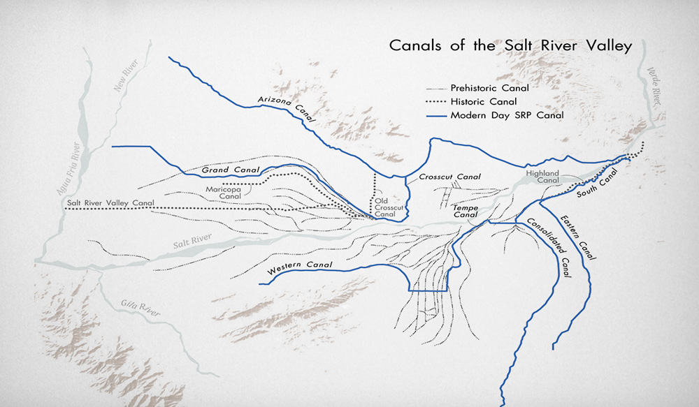
Major canals
Over the past 100-plus years, nine major canals have emerged across the greater Valley.
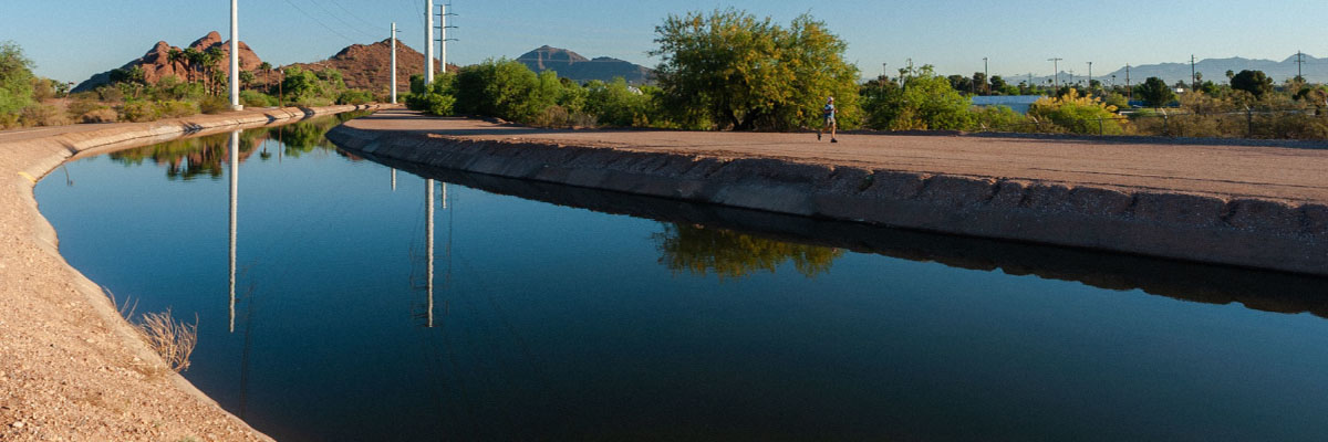
The canal banks were opened for recreational activities in 1964. See what activities you can enjoy along a canal path near you.
Arizona Canal (1883)
Measuring more than 38 miles long, the Arizona Canal is the longest canal in SRP’s system. It’s the main canal that transports water to all others on the north side of the Salt River, and it generally marks the northern boundary of SRP’s water service territory.
The canal was the work of the Arizona Canal Company, which was formed in December 1882. Construction began in May 1883 and was completed in 1885. Water began flowing the next year. The Arizona Canal helped bring water to the north and across to the West Valley, allowing for development of these areas.
The original heading was the old Arizona Dam, located on the Salt River about a mile below the mouth of the Verde River. Unfortunately, that dam was destroyed in a spring flood in 1885. A stronger Arizona Dam was rebuilt by December 1886. Though the second Arizona Dam was the only pioneer diversion dam that survived the big flood of February 1891, it was damaged by a flood in 1905 during the construction of Roosevelt Dam. In an effort to unify the Valley’s water delivery system, the Secretary of Interior agreed to purchase the canal in 1906. The government assumed operations of the Arizona Canal in May of 1907.
Grand Canal (1878)
The Grand Canal is the oldest remaining pioneer canal on the north side of the Salt River. It was planned in 1877 and constructed in 1878 by the Grand Canal Company. The original heading of the Grand Canal was plagued by washouts, which would interrupt its water supply for months at a time, so the Old Crosscut Canal was built to provide a more reliable water supply from the Arizona Dam and the Arizona Canal. Today, the Grand Canal receives water from the Arizona Canal by way of the New Crosscut Canal.
The Grand Canal provided a better route for service of central Phoenix than the Salt River Valley Canal, which led to the abandonment of the Salt River Valley Canal in 1925. The federal government purchased the Grand Canal for $25,731 in June 1906, and it became part of SRP. At that time, the canal served about 17,000 acres.
The Crosscut Canals: Old and new (1889 and 1912)
The Old Crosscut Canal was built near 48th Street by the Arizona Improvement Company to unify the entire northside canal system by connecting the Arizona and Grand canals. After the New Crosscut was built near 64th Street, the Old Crosscut was used only for drainage, emergency flood relief or during repairs to the New Crosscut. In 1975, SRP transferred the maintenance responsibilities for the Old Crosscut to the Flood Control District of Maricopa County and the City of Phoenix, which made improvements to increase the canal’s capacity for flood control.
The New Crosscut (or Arizona Crosscut) was financed and built by the Water Users’ Association in 1912 and turned over to the U.S. Bureau of Reclamation upon completion in 1913. This canal leaves the Arizona Canal near 64th Street and crosses Papago Park before it drops 116 feet through penstocks (pipes) to the Crosscut Hydroelectric Generating Station south of Washington Street. Then it enters the Grand Canal. The completion of the New Crosscut Canal and hydro plant made electric power generation possible on the canals while still allowing for the efficient delivery of irrigation water.
When it was built, the Crosscut Hydro Plant was the second-largest generating station on the SRP system (after Roosevelt Dam).
The New Crosscut Canal’s bank is where the Valley’s first concrete canal-side bicycle path was built in 1975.
South Canal (1908)
The South Canal serves the very important purpose of taking water from the Salt River at the Granite Reef Diversion Dam to all of the other canals on the south side of the Salt River. The South Canal was built by the federal government between 1907 and 1909 to unify the entire southside canal system. Originally, the South Canal was only 2 miles long before splitting into the Consolidated and Eastern canals. However, the Consolidated Canal, nearer to the river, was repeatedly damaged by floods. In 1920, the Eastern Canal was widened to become the main canal for the southside system. The entire 10-mile stretch to the division gates where the Consolidated and Tempe canals separate is now called the South Canal. The first South Canal hydro plant, built in 1912 at the split of the Consolidated and Eastern canals, was moved to its present site in 1924 to take advantage of a drop in the canal. From 1927 to 1929, the South Canal and parts of the Eastern and Consolidated canals were the first SRP canals (and among the first in the nation) lined with concrete. The concrete liner saved water and increased the supply to SRP and the Roosevelt Water Conservation District (RWCD).
The three most significant features along the canal are the Val Vista Water Treatment Plant, the Hennessy Wasteway and the South Consolidated Hydroelectric Plant.
The Hennessy Wasteway is used to discharge excess rainwater from the Salt River. It is also used as the turnout to the Granite Reef Underground Storage Project (GRUSP). Located on a 350-acre site southwest of Granite Reef Diversion Dam, GRUSP stores water from the Salt River and water delivered through the Central Arizona Project. Water is contained at the site and allowed to sink into the ground, recharging the underground aquifer and bolstering groundwater resources. Managed by SRP, GRUSP is a partnership among SRP, six Valley cities and the Salt River Pima-Maricopa Indian Community.
Another feature on the South Canal is the RWCD pumping plant, which takes water from the South Canal into the RWCD Canal. West of Lindsay Road, the South Canal splits and becomes the Eastern Canal to the southeast and the Consolidated Canal to the southwest.
Eastern Canal (1909)
The Eastern Canal is a branch of the South Canal that originates west of Lindsay Road near McDowell Road in northeast Mesa. Built by the federal government in 1909, the Eastern Canal replaced the old Highland Canal, which was one-quarter mile to the west. The Highland Canal had been completed in 1888.
Concerns about water rights, coupled with droughts in the late 1890s and early 1900s, helped motivate landowners served by the Highland Canal to pledge their property as collateral to form the Association. Today, the Eastern Canal is the site of the town of Gilbert’s water filtration plant.
Consolidated Canal (1891)
Although it is the largest canal in Mesa (roughly 18 miles long), the Consolidated Canal wasn't built to serve any of the land within the present city limits.
Started in 1891, the canal was masterminded by Dr. A.J. Chandler and his Consolidated Canal Company. Chandler's desire was to bring water to the area that now bears his name.
Because the canal was built during one of the driest periods in the Salt River's history, its owners faced supply problems. Lands with older water rights had first claim on the meager water supply in the Salt River, and the occasional surpluses that occurred were too small to cultivate new land.
Nevertheless, Chandler was imaginative. Recognizing the problems that owners of the Mesa and Tempe canal companies were having with brush diversion dams, he began bargaining.
In exchange for water to be saved by his proposals, Chandler offered to build a new diversion dam made of huge boulders. The south end of the dam tied into granite masonry abutments and wing walls – the head of the new canal.
Using a huge dredge, Chandler built a canal up to 26 feet deep. Two miles south of the heading, the canal emptied some of its water into the old Mesa Canal. The Consolidated Canal then divided into two branches as it does today. The Consolidated Canal also delivers to the Chandler Water Filtration Plant, which is located south of Pecos Road.
The branch heading west was called the Crosscut Canal, and for about two miles, it followed what is now Brown Road to the edge of a small mesa near the Tempe Canal. This spot is where Chandler built the Chandler Falls Power Plant that provided electricity to Mesa and Tempe.
By carrying Tempe Canal water through the Consolidated Canal, instead of through a sandy riverbed, canal owners were able to prevent a considerable amount of water loss from seepage. This "new" water became part of the Consolidated Canal, which followed the old Mesa Canal to Baseline Road and on to Chandler.
Recognizing the water savings that the Consolidated Canal made possible, the federal government later sought to acquire the canal as part of a unified water distribution system for the Association. Government engineers saw that all canals south of the Salt River could be interconnected by building a new 6-mile length of canal from Granite Reef Diversion Dam to the Consolidated Canal.
Negotiations to buy the Consolidated Canal began in 1907. It was sold to the government in November 1908 for $187,000.
Tempe Canal (1871)
The Tempe Canal is the oldest continuously used canal in SRP’s system. Construction of the Tempe Canal was undertaken by the Tempe Irrigating Canal Company, which had originally been incorporated in 1870 as the Hardy Irrigating Canal Company, though the name was changed the following year. The first Tempe Canal headed in the Salt River near what is now Mesa Drive in Mesa. It flowed along 8th Street to downtown Tempe and on to the west where it also supplied the San Francisco Canal. (This route is still served by laterals, mostly piped.) A branch served the Broadway-Alameda area south of downtown. By 1875, as much as 3,800 acres were being irrigated from these branches. In the 1880s, further branches were dug south along Price Road (a portion now known as the Tempe Canal), west along Guadalupe Road and around the base of South Mountain to south Phoenix. Ultimately, these canals irrigated over 25,000 acres.
Charles Trumbull Hayden, the "Father of Tempe," was among the early homesteaders served by the canal. He first came to the Valley in 1870 and saw the need for a store, ferry service and flour mill at the river near what is now Mill Avenue. Hayden began building the mill in 1872. It began operation two years later, using power generated by water from the Tempe Canal by way of an extension ditch. Some of the earliest pioneers in this area were the Sotelo and Gonzales families, who both worked on the construction of an early branch of the Tempe Canal, the McKinney-Kirkland Ditch, and farmed in the area as well.
Due to solid water rights, Tempe Canal landowners did not join the Association when it was formed in 1903. Most landowners saw no reason to pledge their land as collateral for a federal government loan to build Roosevelt Dam. The Tempe Canal Company finally joined the Association in 1923, but not because of a shortage of water.
The increase in irrigation brought about by Roosevelt Dam raised the water table all over the Valley. Because of geological formations, land in Tempe was at high risk for waterlogging. The Association had the resources — including the electric power — to drain these lands with pumps, and its commitment to make Tempe a priority for drainage convinced the Tempe farmers to join the Association.
Western Canal (1912–1913)
The Western Canal was built to serve SRP lands in south Phoenix after the U.S. government tried but failed to purchase the Wormser Branch of the Tempe Canal. From 1911 to 1912, the government dug the canal from Price Road to 48th Street before suspending work due to funding problems. The government also built three feeder laterals to bring a water supply from the Consolidated Canal and a siphon to carry the Western Canal under the Tempe Canal. Farmers in the south Phoenix area formed the Western Canal Construction Company in 1912 to fund and build the canal from 48th Street to 19th Avenue. When completed, this section was deeded to the U.S. Bureau of Reclamation and the farms of south Phoenix finally had an assured supply of SRP water.
Some farmers in south Tempe and south Phoenix had lands on the lower slopes of South Mountain, which was above the Western Canal. In 1912, these farmers formed the Highline Canal Construction Company and sold stock. They raised $100,000 to build a pumping plant, pipeline and canal. The pumping plant took water from a bay in the Western Canal and pumped it 40 feet uphill through a 1-mile pipe, where it emptied into the Highline Lateral for distribution.
From the Tempe Canal, the Western Canal heads west then turns and curves around to the northwest along the foothills of South Mountain. Roughly at the Maricopa Freeway, the canal continues its western jaunt, then dips to the southwest near 7th Avenue.
Drivers traveling along Baseline Road between the freeway and Central Avenue can see the Western Canal just north of the road. The Western Canal now has the Highline Pumping Plant, located east of Kyrene Road, to lift water to the Highline Canal.
The Central Arizona Project (1968)
As the state grew, SRP and other water providers understood that additional water supplies would be necessary to support Arizona's cities, agriculture, business and industry, so SRP helped advocate to bring a new reclamation project, the Central Arizona Project (CAP), to life. The CAP's canal system transports water across the desert from the Colorado River, carrying it to the state’s central valley where it adds to the region’s supply.
Laterals
SRP's irrigation system includes hundreds of smaller waterways that connect to the main canals. These ditches, called laterals, take water from the large canals to delivery points in irrigated areas. Of the 1,074 miles of drains and laterals, over 85% have been piped to help reduce water loss — and more are lined or piped each year.
Water is routed into and through these laterals by a series of turnout gates. Residential irrigation customers take their water entitlement at regularly scheduled intervals throughout the year by opening valves that release water onto their property for specific time periods.
Most laterals north of the Salt River in urban areas are underground. Many of the laterals that take water from canals in agricultural areas south of the river are open ditches.
RELATED TOPICS
About Salt River Project | SRP
SRP is a community-based, not-for-profit organization providing affordable water and power to more than 2 million people in central Arizona. Read more here.

History of Salt River Project | SRP
Since 1903, Salt River Project has helped shape our state. Learn about our history of service to the people who call Arizona home.

SRP historical timeline | SRP
Formed before Arizona was officially a state, SRP and the communities we serve have grown together for more than a century. See a historical timeline here.